Staff writer, with CNA
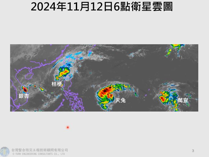
Tropical Storm Usagi strengthened to a typhoon yesterday morning and remains on track to brush past southeastern Taiwan from tomorrow to Sunday, the Central Weather Administration (CWA) said yesterday.
As of 2pm yesterday, the storm was approximately 950km east-southeast of Oluanpi (鵝鑾鼻), Taiwan proper’s southernmost point, the CWA said.
It is expected to enter the Bashi Channel and then turn north, moving into waters southeast of Taiwan, it said.
The agency said it could issue a sea warning in the early hours of today and a land warning in the afternoon.
As of 2pm yesterday, the storm was moving at 24kph.
Usagi could bring scattered or isolated rain showers to much of Taiwan, particularly in the eastern counties of Hualien and Taitung and on the Hengchun Peninsula (恆春半島) in the south, when it is closest to Taiwan from tomorrow to the early hours of Sunday, it said.
The Forestry and Nature Conservation Agency urged people not to visit mountainous areas when the typhoon comes close to the nation.
National forest recreation areas and forest railway services in eastern and southern Taiwan might be closed for precaution from today, it said.
People who are planning to visit such areas or take the trains are advised to check the weather forecast and the agency’s Web site before traveling, it said.
In addition to Usagi, there are two other tropical storms in the Western Pacific — Toraji and Man-yi — although neither is expected to directly affect Taiwan, the CWA said.
A typhoon is defined by wind speeds of 118kph or above, while tropical storms have wind speeds of 62kph to 117kph.
Rotating storms with winds weaker than 62kph are referred to as tropical depressions.
新聞來源:TAIPEI TIMES
2024/11/14 04:30
轉載自自由時報電子報: https://news.ltn.com.tw/news/focus/breakingnews/4862241


